There's something almost poetic about the old named highways of early America. The Lincoln Highway. The Dixie Highway. The National Old Trails Road. The Jefferson Davis Highway. They sounded like something out of a John Steinbeck novel — roads with personalities, roads that meant something beyond their asphalt.
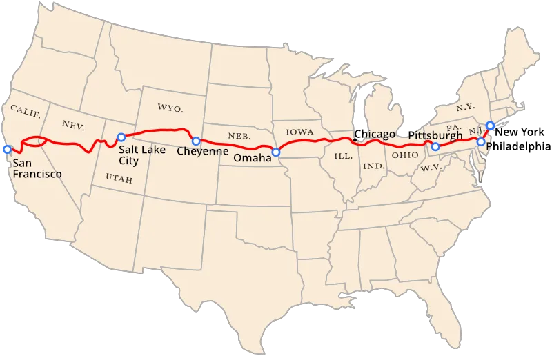 Photo: Lincoln Highway, via www.lincolnhighwayassoc.org
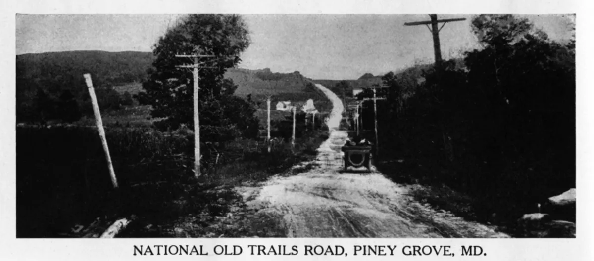 Photo: National Old Trails Road, via www.americanroads.us
Then the federal government got involved, and all of that romance got replaced with numbers.
Today, US Route 66 carries a certain nostalgic weight — but that's the exception. Most Americans navigate by number without a second thought, treating Route 40 or Interstate 80 as neutral facts of geography rather than the product of one of the messiest bureaucratic fights in American transportation history. The story of how names became numbers is less a triumph of rational planning than a survival of the least-bad compromise.
The Named Highway Chaos
Before the federal government standardized anything, highway naming was essentially a free-for-all run by private highway associations. These were organizations — often funded by local boosters, chambers of commerce, and automobile clubs — that would designate a route, give it a romantic name, put up their own signs, and then aggressively promote it to drivers and travel writers.
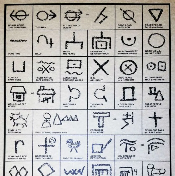
By the early 1920s, there were more than 250 named trails crisscrossing the country. Some were genuinely useful, connecting major cities along reasonably logical corridors. Many were not. Competing associations would sometimes claim the same stretch of road for different named highways, resulting in telephone poles plastered with a half-dozen different colored bands, each representing a different route. Travelers following the markers of one highway would suddenly find themselves on a completely different road because a local booster had redirected the signs to route traffic through his town's main street.
The Lincoln Highway Association, founded in 1913, was the most prominent and professionally run of these organizations. But even the Lincoln Highway — the first transcontinental route — was inconsistently marked and maintained, varying wildly in quality from state to state depending on local enthusiasm and funding.
For ordinary drivers, it was a navigational nightmare. Road maps from the era are almost comically complex, covered in overlapping colored lines representing named routes that bore no logical relationship to each other's numbering or direction.
The AASHO Showdown
The American Association of State Highway Officials — AASHO, the predecessor to today's AASHTO — convened a joint committee with the federal Bureau of Public Roads in 1925 to address what everyone agreed was an unsustainable mess. The goal was to create a unified national system of numbered routes that would replace the patchwork of named highways.
What followed was two years of genuinely fierce political argument.
The highway associations weren't going to give up their named routes without a fight. The Lincoln Highway Association in particular had spent more than a decade building the brand value of its route — raising money, lobbying for improvements, and marketing the highway to a generation of American motorists. Replacing it with a number felt like an erasure.
State governments had their own axes to grind. Every state wanted the prestigious low numbers — US Route 1, US Route 2 — running through its territory, since low numbers implied importance and would attract tourism and commerce. The negotiations over which routes got which numbers became a proxy war for regional pride and economic competition.
The east-west versus north-south numbering convention — odd numbers for routes running north-south, even numbers for east-west — was one of the few things the committee agreed on relatively quickly. It was logical, scalable, and borrowed from grid-based city planning principles that most engineers already understood.
Everything else was a fight.
The Compromise Nobody Loved
The system that emerged in 1926 was, by most accounts, a political settlement rather than an elegant design. Routes were numbered based on a combination of geographic logic and horse-trading. The lowest numbers went to routes on the eastern and northern edges of the country — US Route 1 running up the Atlantic coast, US Route 2 running across the northern tier — with numbers increasing as you moved south and west.
The named highway associations were not abolished. They simply became irrelevant. Without official recognition or government signage, the Lincoln Highway and its counterparts gradually faded from practical use, surviving mostly in the memories of an older generation of drivers and, eventually, in nostalgia.
Route 66 became the famous exception — a numbered highway that somehow acquired the cultural weight of a named road, thanks largely to John Steinbeck's "The Grapes of Wrath" and later the television series that bore its name. But Route 66's fame was accidental. The number itself was almost assigned to a different route; 66 was chosen partly because it was available and had a pleasing sound.
The Elegance Nobody Planned
Here's the genuinely surprising part of this story: the system that emerged from all that bickering actually worked beautifully. The odd-even convention made intuitive sense once you knew it. The numbering pattern — low numbers in the east and north, high numbers in the west and south — gave drivers a rough mental map of where they were in relation to the country. The shield-shaped US Route sign became one of the most recognizable pieces of graphic design in American history.
None of this was the result of visionary planning. It was the residue of a committee argument that nobody fully won. The elegance came later, as drivers learned the system and found it more useful than the romantic chaos it replaced.
The interstate highway system, built starting in the 1950s, borrowed and refined the same logic — even numbers east-west, odd numbers north-south, with three-digit numbers for urban spurs and loops. The framework established in 1926 turned out to be sturdy enough to absorb an entirely new category of highway without breaking.
What Got Lost
There's a real cost to the numbering system, and it's worth acknowledging. The named highways had a relationship to place and history that numbers never quite replicate. The National Old Trails Road followed routes used by pioneers and, before them, by Native American nations. The Dixie Highway connected communities across the South in ways that mattered economically and culturally to the people who lived along it.
Numbers are neutral. That's their strength as a navigation system, and it's also their limitation as a record of how Americans moved across their own country.
The Lincoln Highway Association, to its credit, never entirely disappeared. It still exists today as a historical organization, maintaining markers and archives that document what the named highway era looked like before the committee got to work.
The roads are still there. They just go by different names now. Numbers, mostly.